
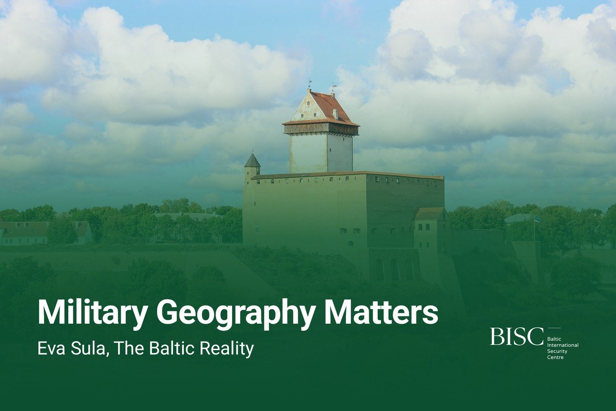
Featured image: Narva Castle by the Narva River, September 7, 2023. Photo: KalervoK, CC0, via Wikimedia Commons.

The Baltic Reality | Part 1 of 5
By Eva Sula
Editor’s note: This is Part 1 of Eva Sula’s five-part series The Baltic Reality: Beyond the Red Arrows. BISC added the maps and the visuals. They are not part of her original article, which appears here as she wrote it.
All opinions expressed are those of the author alone and may not represent those of the institutions they represent or the Baltic International Security Centre (BISC). BISC maintains a strict intellectual independence policy across all its projects and publications.
© Eva Sula
First published on LinkedIn on July 17, 2026. Read the original article or the LinkedIn post.
Introduction
Discussions about Baltic security often begin with political maps, simplified invasion scenarios and assumptions that do not reflect the geographical, historical and operational realities of the region. Military geography remains one of the most overlooked aspects of contemporary security debates despite continuing to shape deterrence, defence planning, military mobility and operational possibilities.
The Baltic States are frequently discussed as a single strategic problem set. They are not. Estonia, Latvia and Lithuania share common security interests and historical experiences, but they differ considerably in their geography, infrastructure, strategic dependencies and military considerations. Understanding those differences matters when discussing regional security and alliance planning.
Before asking how a conflict in the Baltic region might unfold, it is worth asking a more fundamental question: what does the Baltic region actually look like from a military and strategic perspective? Political maps explain where borders are. They do not explain how terrain, weather, infrastructure, operational mobility or regional dependencies shape military realities.
This series begins with military geography because geography has not become less important in modern warfare. If anything, modern multi-domain operations have made understanding the physical environment more important, not less.
Section 1. The Baltics Are Not One Country
The Baltic States are frequently discussed as a single strategic entity in defence and security debates. The term “the Baltics” is useful when referring to regional cooperation, NATO’s northeastern flank or shared geopolitical interests. It is considerably less useful when it becomes shorthand for assuming that Estonia, Latvia and Lithuania face identical strategic realities or military considerations.
The three Baltic States share important historical experiences and common security interests. They have rebuilt their independence after decades of Soviet occupation, are members of both NATO and the European Union, and have spent more than three decades developing their defence and security institutions while living alongside an increasingly assertive Russia. These shared experiences explain why they are often discussed together in European and transatlantic security discussions.
At the same time, treating the Baltic States as a homogeneous region risks oversimplifying the very factors that shape deterrence, defence planning and operational realities. Geography, infrastructure, regional dependencies and military considerations differ considerably across the region. Understanding those differences is fundamental to understanding Baltic security.
Why “The Baltics” Is an Oversimplification
The Baltic States are not strategically interchangeable. Estonia’s strategic environment is shaped by the Gulf of Finland, its maritime connections, its relationship with Finland and the Narva River and Lake Peipus system along its eastern border. Lithuania operates in an entirely different geographical and strategic environment, sharing borders with both Belarus and Poland while playing a central role in NATO’s land-based reinforcement considerations. Latvia occupies its own unique position between the two, with different terrain characteristics, infrastructure considerations and regional dependencies.
Estonia, Latvia, Lithuania and their neighbours
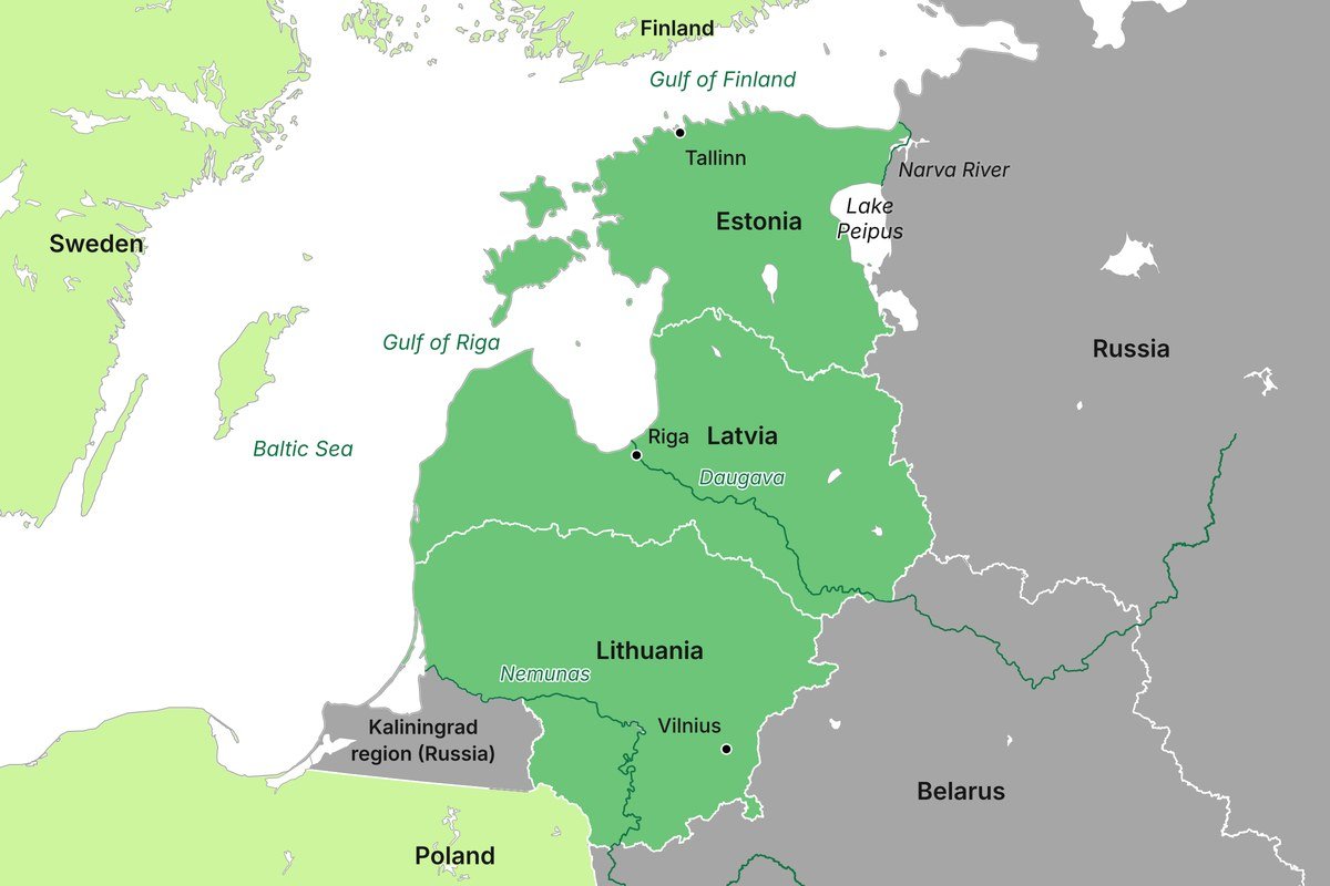
Map: BISC. Borders and rivers: OpenStreetMap contributors.
These differences matter because military planning does not begin with political borders. It begins with understanding terrain, infrastructure, mobility, logistics and the wider operational environment. Strategic assumptions that may be valid for one Baltic State are not automatically transferable to another.
Grouping the Baltic States together remains useful when discussing alliance planning, regional cooperation and common security challenges. It becomes problematic when regional labels replace country-specific analysis.
Shared Strategic Realities
The Baltic States share more than geography. Their historical experiences have shaped contemporary approaches to defence and preparedness in ways that are often underappreciated outside the region.
All three countries restored their independence following the collapse of the Soviet Union and have developed defence policies that reflect both historical experience and contemporary security realities. NATO and EU membership, societal resilience, regional cooperation and strong support for Ukraine are not recent developments or temporary political trends. They are part of broader strategic choices that have been shaped over decades.
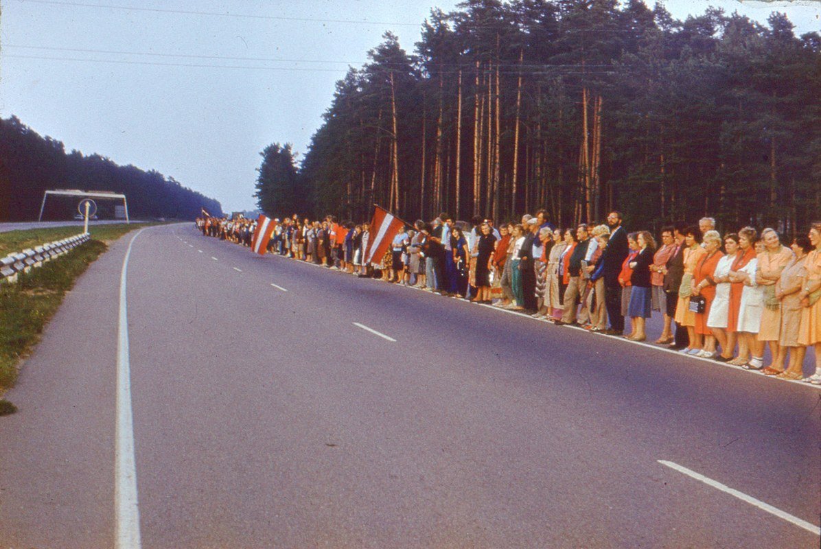
People stand in the Baltic Way, the human chain through Estonia, Latvia and Lithuania, along a highway near Inčukalns, Latvia, August 23, 1989. Photo: Marika Valdusa, CC BY-SA 4.0, via Europeana 1989.
Living alongside Russia has also meant that questions of defence, resilience and preparedness have never been purely theoretical exercises. The Baltic States have approached these questions differently over time, but they have done so with a shared understanding that geography and history continue to matter.
These common characteristics explain why the Baltic States are frequently analysed together in NATO and European security discussions. They do not, however, eliminate the considerable differences that exist between them.
Geography Creates Different Military Realities
Military geography remains one of the most important variables in defence planning because it cannot be negotiated, redesigned or ignored. It shapes operational mobility, infrastructure requirements, force posture considerations and strategic dependencies.
Estonia’s geography presents a different operational picture from that of Lithuania. Maritime considerations in the Gulf of Finland, island defence, river systems and connections to the wider Nordic region create specific military and strategic considerations that differ significantly from those associated with Lithuania’s borders with Belarus and Poland or Latvia’s terrain and geographical position within the Baltic region.
The same applies to questions of military mobility and logistics. Terrain influences how military forces move, where infrastructure matters most and which assumptions are operationally realistic. Discussions about Baltic security that begin with generic invasion scenarios or simplified political maps often overlook these realities.
Military geography does not provide easy answers. It provides constraints, opportunities and dependencies that must be understood before meaningful strategic analysis can begin.
Infrastructure and Strategic Dependencies
The Baltic States are geographically small but strategically interconnected. Their security environment extends well beyond their national borders and cannot be understood in isolation.
Ports, roads, railways, energy infrastructure and maritime connections shape both national resilience and alliance planning. The Baltic Sea, the Gulf of Finland and the broader Nordic-Baltic region play an essential role in contemporary security considerations. Finland, Sweden, Poland, Denmark and NATO’s wider force posture are all part of the Baltic strategic environment.
This interconnectedness has become even more apparent following Finland’s and Sweden’s accession to NATO. Security considerations that were once discussed primarily within national frameworks increasingly need to be understood at the regional level.
Analysing Baltic security as a purely national or purely regional question therefore produces incomplete conclusions. Both perspectives are necessary.
Section 2. Political Maps Versus Military Geography
Political maps are excellent tools for understanding sovereignty, international borders and alliances. They are considerably less useful when discussing military realities. One of the most common mistakes in contemporary security debates is assuming that political geography and military geography are interchangeable. They are not.
Military planners do not begin their assessments by drawing arrows across borders. They begin by asking a series of practical questions about terrain, infrastructure, mobility, logistics, environmental conditions and strategic dependencies. The answers to those questions shape what is operationally possible, what is difficult to achieve and what assumptions are required before military capabilities can be meaningfully discussed.
This distinction matters because political maps are inherently two-dimensional representations of highly complex operational environments. They do not explain terrain, infrastructure, seasonal conditions or the countless constraints that shape military operations. They show where borders are. They do not explain how military forces would move, operate or sustain themselves in practice.
What Military Planners Actually Analyse
Military geography is considerably more than studying the location of states or the length of borders. It is the analysis of how geography influences military planning, operational mobility, logistics, force posture and strategic decision-making.
Military planners routinely consider factors such as:
- terrain and topography;
- rivers, lakes and wetlands;
- coastlines and maritime approaches;
- infrastructure and transport networks;
- operational mobility and sustainment;
- strategic depth and chokepoints;
- seasonal and environmental conditions;
- intelligence and situational awareness requirements;
- regional and allied dependencies.
Each of these factors influences how military operations are planned and executed. Military capabilities do not operate independently of their environment. The same capability can produce very different operational outcomes depending on where, when and under what conditions it is employed.
Operational planning is therefore fundamentally an exercise in understanding constraints as much as capabilities. Geography does not determine outcomes, but it does shape the opportunities, limitations and risks that decision-makers must consider.
Every Arrow Represents Thousands of Assumptions
Simplified invasion maps are useful for illustrating broad strategic concepts. They are considerably less useful when presented as operational realities without explaining the assumptions required to support them.
Every arrow drawn across a political map represents a series of operational questions that must be answered before military movement can occur.
Those questions include:
- Is the terrain suitable for military movement?
- Which infrastructure is available and operational?
- What engineering capabilities are required?
- What are the environmental and seasonal conditions?
- What intelligence and surveillance capabilities are available?
- What logistical requirements must be sustained?
- What civilian and military dependencies exist?
- How contested is the operational environment?
- What strategic and political objectives are being pursued?
An arrow on a map communicates direction. It does not explain operational complexity. Military analysis becomes problematic when outcomes are assumed without first examining the conditions necessary to achieve them.
Every arrow drawn on a map represents thousands of operational assumptions that are rarely explained. Strategic analysis should begin by examining those assumptions rather than treating them as self-evident.
Geography Shapes Strategic Choices
Military geography influences defence planning at every level. It shapes infrastructure investments, alliance planning, force posture decisions, military mobility considerations and regional cooperation.
Countries do not organise their defence institutions, capabilities or preparedness models in isolation from their geography. Geography influences which capabilities are prioritised, which vulnerabilities require mitigation and which strategic partnerships become operationally important.
The Baltic States are no exception. Their geographical realities influence national defence planning and regional security considerations in ways that are often overlooked in broader European security discussions. Understanding military geography is therefore not an academic exercise or a historical curiosity. It remains a practical requirement for meaningful strategic analysis and informed decision-making.
Section Conclusion
Political maps remain valuable tools for understanding borders and sovereignty. They are not sufficient for understanding military realities. Military planners analyse terrain, infrastructure, operational mobility, logistics and strategic dependencies because geography continues to shape what is operationally possible.
Before discussing military capabilities, reinforcement timelines or conflict scenarios in the Baltic region, it is necessary to understand the geographical and operational environment in which those capabilities would have to function. Military geography has not become less important in the age of multi-domain operations. If anything, modern warfare has made understanding the physical environment more important, not less.
Section 3. Mother Nature Is a Military Planner
Military geography extends far beyond political borders and terrain analysis. Weather, environmental conditions and seasonal changes continue to shape military mobility and operational realities despite advances in military technology. Modern warfare has not eliminated geography. Military forces still operate within physical environments that impose constraints, create opportunities and influence strategic choices.
Military planners do not analyse terrain as a static feature of a map. Rivers flood, wetlands shift, coastlines create maritime constraints, ice forms and melts, infrastructure becomes degraded and environmental conditions can fundamentally alter operational possibilities throughout the year. The same geographical area may present entirely different military considerations depending on the season, weather conditions and operational objectives.
Mother Nature is not Estonia’s ally. She is indiscriminate and a deeply unpleasant military planner. The advantage belongs to whoever understands her first.
Terrain Shapes Military Mobility
Military mobility is highly dependent upon environmental conditions. Terrain influences where military forces can move, how quickly they can operate and what capabilities are required to sustain operations.
Rivers, lakes, wetlands, peatlands, forests, coastlines and islands are not simply geographical features. They represent operational variables that military planners must account for when assessing mobility, infrastructure requirements and logistical considerations.
Military geography matters because it imposes practical constraints. Land is not automatically traversable simply because it appears connected on a political map. Environmental conditions frequently dictate which routes are suitable for movement and which are operationally problematic.
The Baltic region provides an excellent example of how geography shapes military realities. Estonia alone has more than 2,300 islands and islets, approximately 3,800 kilometres of coastline when the islands are included, more than 50% forest coverage and extensive wetland and peatland areas. Depending on the methodology used, wetlands, bogs and peatlands account for approximately one-fifth to one-quarter of the country’s territory. These geographical characteristics influence infrastructure planning, military mobility and operational considerations regardless of the capabilities employed.
Latvia and Lithuania present different geographical realities, but both countries have also invested significantly in restoring and protecting wetlands, peatlands and natural ecosystems in recent years. These initiatives are primarily driven by environmental and climate objectives. Military planners, however, have long understood that terrain influences mobility and operational possibilities. Natural barriers remain natural barriers regardless of whether they are viewed through the lens of environmental protection or defence planning.
Forest and bog in Estonia, Latvia and Lithuania
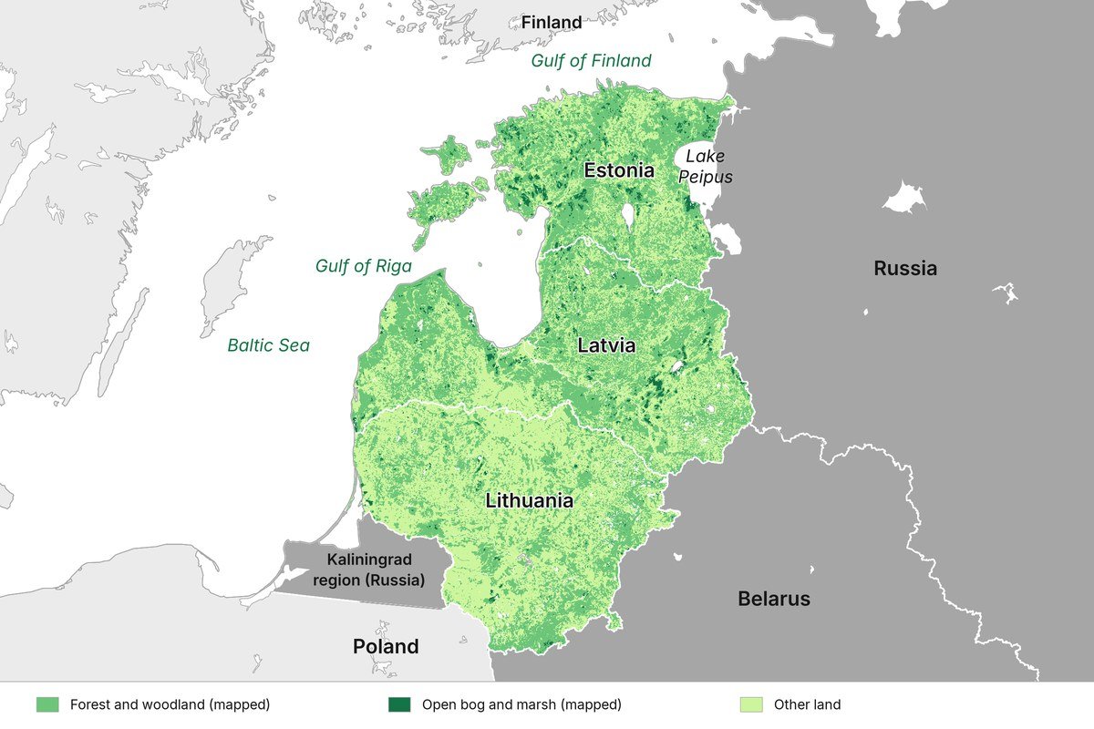
Map: BISC. Land cover: Copernicus Land Monitoring Service, CORINE Land Cover 2018. Borders: OpenStreetMap contributors.
Weather Changes Operational Realities
Weather remains one of the most underestimated variables in contemporary security discussions.
Seasonal changes influence military mobility, visibility, infrastructure, logistics and maritime operations. Freeze-thaw cycles can dramatically alter terrain conditions within relatively short periods of time. Mud seasons continue to influence operational mobility in ways that modern conflicts have repeatedly demonstrated. Ice conditions may enable or restrict movement depending on location and environmental circumstances. Sea state and visibility influence maritime and air operations throughout the Baltic region.
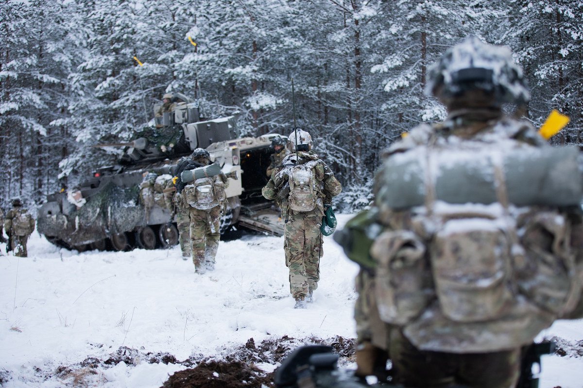
U.S. Army soldiers of the 7th Cavalry Regiment walk towards a Bradley fighting vehicle in a snowy forest near Tapa, Estonia, during Nato’s Winter Camp exercise, February 3, 2025. Photo: Pfc. Nathan Arellano Tlaczani, U.S. Army, public domain, via Wikimedia Commons.

Climate change adds another layer of complexity. Milder winters do not necessarily simplify military planning. They often create more unpredictable environmental conditions, shorter periods of stable frozen ground and increased variability in seasonal patterns. The Baltic States are increasingly experiencing warmer winters, prolonged periods of rain and rapidly changing environmental conditions that influence both civilian and military infrastructure.
Modern military capabilities remain subject to environmental realities. Technology may mitigate certain constraints, but it does not eliminate them.
Estonia as a Case Study in Military Geography
Estonia’s geography illustrates particularly well why military planners analyse terrain rather than political borders.
Large parts of the country are characterised by forests, wetlands, bogs, peatlands, lakes, rivers, maritime approaches and island environments. Operational mobility is therefore highly dependent upon terrain, infrastructure and seasonal conditions. More than 50% of Estonia is covered by forests, while approximately one-fifth to one-quarter of its territory consists of wetlands, bogs and peatlands. Estonia also has more than 2,300 islands and islets and approximately 3,800 kilometres of coastline when islands are included. None of these geographical realities are particularly accommodating to large-scale military mobility.
Political maps tend to create the illusion that borders are simply lines separating one country from another. Military geography tells a different story. Borders are often defined by terrain features that have shaped military planning for centuries. Rivers remain rivers regardless of technological developments, and wetlands remain wetlands regardless of political narratives.
The geographical realities of Estonia’s eastern border are often overlooked in simplified discussions about Baltic security. Estonia’s eastern border with Russia is approximately 338.6 kilometres long. Significant portions of this border are formed by major natural obstacles rather than dry land. The Lake Peipus-Lämmijärv-Pskov lake system constitutes one of Europe’s largest transboundary lake systems and is complemented by the Narva River, which serves as the only outlet from the entire lake system into the Gulf of Finland.
Lake Peipus itself is approximately 135 kilometres long, while the entire lake system stretches approximately 152 kilometres with a maximum width of approximately 47 kilometres and a total surface area of roughly 3,555 square kilometres. Significant portions of the remaining border areas are characterised by forests, wetlands, peatlands and limited infrastructure corridors that further constrain operational mobility.
From a military perspective, this means that a significant portion of Estonia’s eastern border is water or environmentally complex terrain. There is no uninterrupted strip of dry land extending along the eastern border that simply facilitates military movement. Geography dictates where movement is possible, where infrastructure becomes critical and where military planners must account for significant environmental constraints.
Estonia’s eastern border: the Narva River and the Lake Peipus system
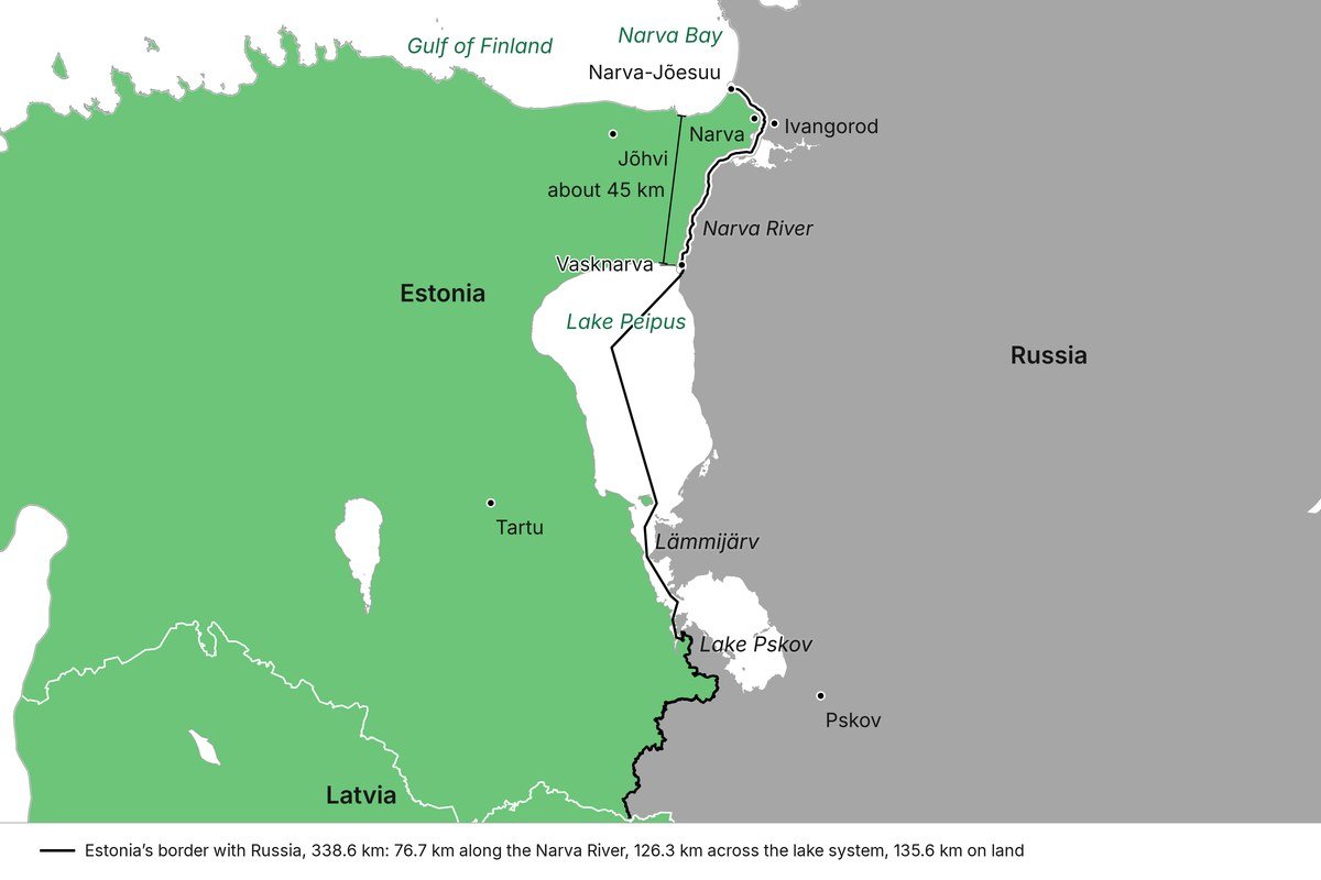
Map: BISC. Border, river and lakes: OpenStreetMap contributors.
Environmental conditions further influence operational mobility throughout much of the year. Estonia experiences prolonged wet periods, autumn rains, freeze-thaw cycles, spring flooding and increasingly unpredictable winter conditions. Terrain that may be traversable during dry summer conditions can become operationally problematic during autumn rains or spring thaw. Military planners therefore do not classify terrain as simply “crossable” or “non-crossable”. They assess terrain in terms of mobility, environmental conditions, required capabilities and acceptable levels of operational risk.
Military mobility is consequently a dynamic variable rather than a fixed geographical characteristic.
The Narva River Is Not a Line on a Map
The Narva River is frequently represented on political maps as a relatively narrow blue line separating Estonia and Russia. Military geography provides a considerably more complex picture.
The river stretches approximately 77 kilometres from Lake Peipus to the Gulf of Finland and is Estonia’s largest river by discharge. It is also the only outlet of the entire Lake Peipus system and the second largest contributor of freshwater into the Gulf of Finland after the Neva River.
Under average hydrological conditions, the Narva River carries approximately 380 to 400 cubic metres of freshwater per second into the Gulf of Finland. During spring flooding and snowmelt periods, discharge levels can increase significantly and have historically exceeded 1,300 cubic metres per second during exceptional hydrological conditions.
Depending on location, the river varies considerably in width and depth. Average widths range between approximately 200 and 400 metres, while some sections approach or exceed 650 metres in width. Its prevailing depth is approximately three to six metres, reaching up to 15 metres in some downstream sections. Average current velocity is approximately one metre per second and may increase significantly at rapids and other geographical features.
The Narva River in numbers
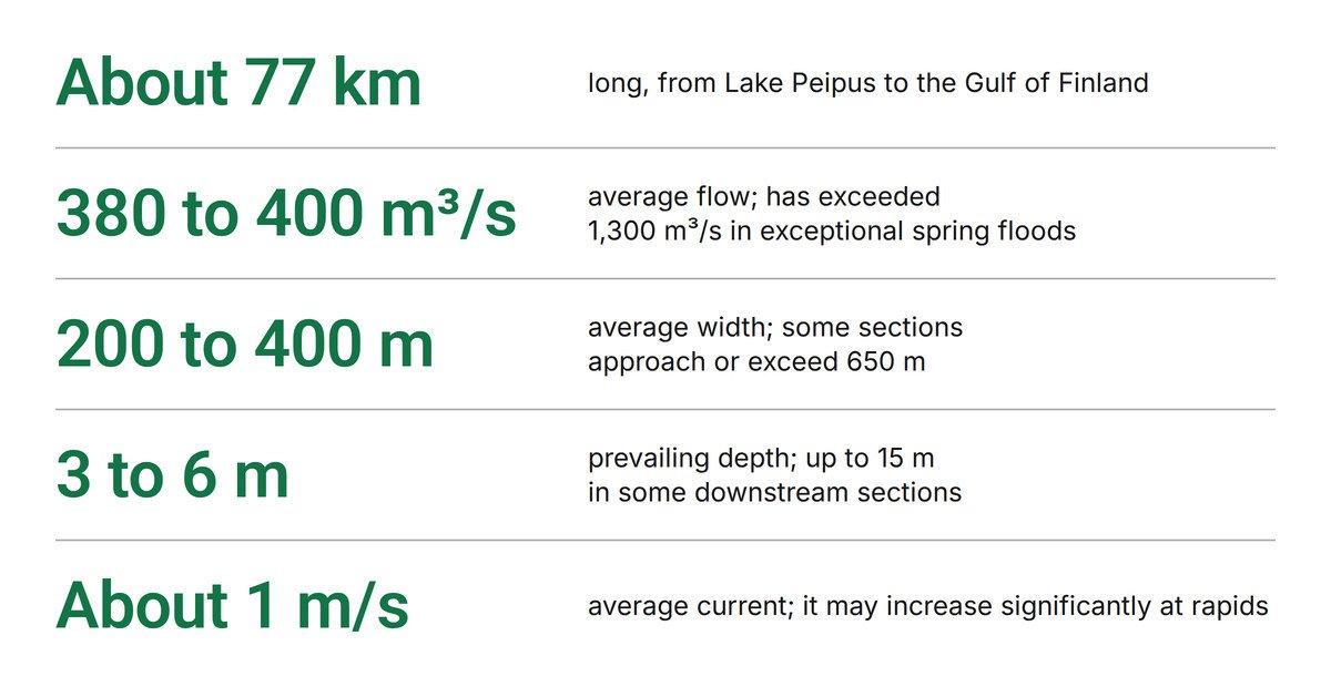
Graphic: BISC.
These figures are not geographical trivia. They are operational considerations.
Crossing a water obstacle of this size and hydrological complexity under contested conditions remains one of the most demanding military engineering tasks regardless of technological sophistication. Successful river crossings require considerably more than identifying a direction of advance on a political map. They require engineering assets, logistical sustainment, force protection, infrastructure considerations and suitable mobility corridors on both sides of the river.
Military planners must therefore ask practical questions:
- Which section of the river is suitable for crossing?
- What engineering capabilities are required?
- What infrastructure dependencies exist?
- How do seasonal and environmental conditions influence mobility?
- What logistical support is required after the crossing?
- How are follow-on forces sustained?
- What vulnerabilities are created during crossing operations?
- What happens if existing crossing infrastructure is degraded or destroyed?
Political maps do not answer these questions. Military geography does.
The Narva River also contains strategically significant hydroelectric and water infrastructure, including dams, reservoirs and power generation facilities that influence water levels and the surrounding terrain. Infrastructure disruptions or deliberate damage would have immediate consequences for both Estonia and Russia. Water does not recognise political borders. Hydrological and infrastructural effects influence mobility, energy production and civilian infrastructure on both sides of the river.
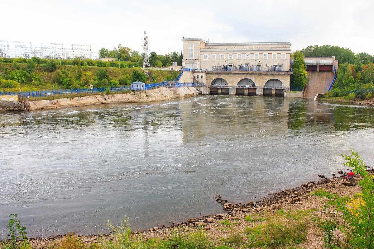
The Narva hydroelectric station and its dam on the Narva River, September 8, 2023. Photo: KalervoK, CC0, via Wikimedia Commons.

Discussions about military geography therefore cannot ignore the realities of shared infrastructure and environmental dependencies. The Narva River is not simply a political boundary. It is a complex geographical, hydrological and infrastructural system that significantly influences operational considerations.
History Matters
Military geography has influenced military operations throughout history and continues to do so today. The Battle of Narva in 1944 remains one of the clearest historical examples of how terrain, waterways, infrastructure and operational mobility shape military outcomes.
The strategically important Narva isthmus between the Gulf of Finland and Lake Peipus is only approximately 45 kilometres wide. This narrow strip of land has historically functioned as a natural chokepoint, forcing military planners to account for limited mobility corridors, constrained infrastructure and environmentally complex terrain. Forests, swamps, waterways and wetlands significantly influenced operational planning throughout the campaign.
Soviet military planners understood these realities well. The offensive against Narva was not a rapid advance across a political border. During the campaign, the Soviet Union concentrated more than 200,000 troops, approximately 2,500 artillery pieces, hundreds of aircraft and significant armoured capabilities in the region. The Battle of Narva lasted approximately seven months, from February until August 1944, and involved extensive artillery bombardment, aerial attacks and sustained offensive operations before Soviet forces successfully advanced westwards. Soviet forces suffered exceptionally heavy casualties during the Narva campaign, with historical estimates ranging from approximately 100,000 dead or missing and roughly 380,000 wounded or sick during the broader campaign in northeastern Estonia. Even more conservative estimates account for tens of thousands of casualties. German and Estonian forces also suffered significant losses, estimated at approximately 58,000 casualties during the campaign.
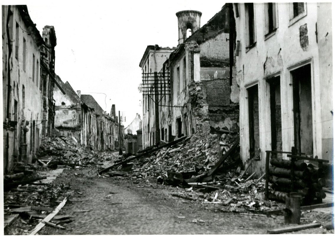
A street in the Old Town of Narva in ruins, 1944. Photo: Unknown photographer, National Archives of Norway (Arkivverket), CC BY-SA 4.0, via Wikimedia Commons.

Perhaps most importantly, Soviet forces did not simply cross the Narva River in a single decisive operation at Narva itself. Multiple bridgeheads were established north and south of Narva, including through the Krivasoo swamp area and via operations connected to the Lake Peipus region. Military planners sought alternative crossing points and mobility corridors precisely because terrain and waterways constrained operational possibilities. Geography channelled movement, dictated infrastructure requirements and significantly influenced operational timelines.
The historical relevance is not that future conflicts would unfold in the same manner. Modern warfare differs significantly from that of 1944. The historical lesson is considerably more fundamental: geography matters.
Military technology evolves. Rivers remain rivers. Wetlands remain wetlands. Weather remains largely indifferent to military ambitions. Geography has never guaranteed military success or failure, but it has consistently shaped the conditions under which military operations take place.
Section 4. Military Mobility Is Not a Hollywood Movie
One of the most persistent misconceptions in public discussions about modern warfare is that military mobility is simply a question of military capability and intent. Possessing tanks, artillery, drones or armoured vehicles does not automatically translate into operational mobility. Military formations do not move in isolation, nor do they operate independently of terrain, infrastructure or environmental conditions.
Political maps and simplified invasion scenarios tend to create the impression that military forces can simply move from Point A to Point B if sufficient military capability exists. Modern military operations are considerably more complex and require the integration of people, capabilities, infrastructure, logistics and planning across multiple domains before the first vehicle even begins moving.
Military mobility should therefore be understood as the ability to deploy, sustain and operate military capabilities under specific operational conditions rather than simply moving military equipment from one location to another.
Combined Arms Operations and Military Mobility
Modern military operations are combined arms operations. Infantry, armour, artillery, engineering units, logistics, intelligence capabilities, air assets, maritime considerations and communications infrastructure must function together to create operational effect.
Moving a military formation requires considerably more than determining a direction of advance. Military planners must consider:
- terrain and trafficability;
- engineering requirements;
- mobility corridors;
- logistical sustainment;
- fuel and ammunition requirements;
- intelligence, surveillance and reconnaissance capabilities;
- air and maritime considerations;
- infrastructure availability;
- environmental conditions;
- civilian infrastructure dependencies;
- contested operational environments.
Military planners therefore assess military mobility in relation to environmental conditions, infrastructure availability, operational risks and the ability to sustain operations once military formations have reached their intended objectives.
Infrastructure Requirements
Military mobility is fundamentally dependent upon infrastructure.
Roads, bridges, railways, ports, airfields, energy infrastructure and communications networks influence how military capabilities are deployed, sustained and reinforced. Infrastructure frequently determines operational possibilities and limitations long before military capabilities themselves become relevant.
Modern military formations consume significant amounts of fuel, maintenance resources and logistical support. Engineering capabilities may be required to repair damaged infrastructure or create temporary mobility solutions. Infrastructure bottlenecks may significantly influence operational timelines regardless of military capability.
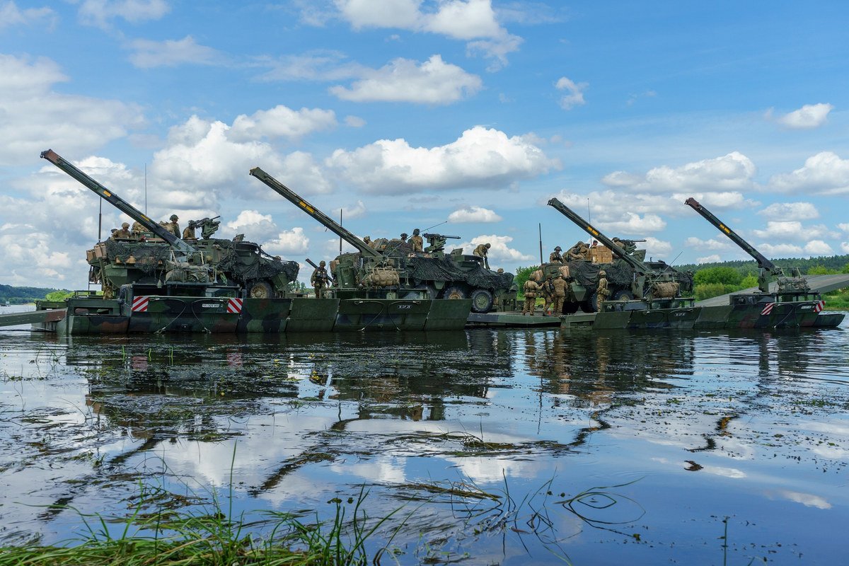
U.S. 2nd Cavalry Regiment vehicles cross the Nemunas near Kulautuva, Lithuania, on German M3 amphibious bridging vehicles during Saber Strike 18, June 13, 2018. Photo: Sgt. Gregory Summers, U.S. Army, public domain, via Wikimedia Commons.

Questions that military planners routinely ask include:
- Which infrastructure corridors are suitable for movement?
- What are the load limitations of existing infrastructure?
- Which routes are operationally viable?
- How resilient is the supporting infrastructure?
- What redundancies exist?
- What infrastructure is vulnerable to disruption?
Infrastructure planning is therefore an integral component of military mobility and operational planning.
Contested Operational Environments
Military mobility rarely takes place in uncontested environments.
Modern conflicts have demonstrated that military formations operate under persistent surveillance and are increasingly vulnerable to intelligence gathering, electronic warfare, precision fires, cyber operations and attacks against critical infrastructure. Operational mobility must therefore be considered within a contested and multi-domain environment.
Movement generates observable signatures. Large military formations require significant supporting capabilities and infrastructure to operate effectively. Mobility corridors may become operational vulnerabilities if adversaries possess the capability to identify, disrupt or deny them.
Operational planning must therefore account for:
- intelligence and reconnaissance capabilities;
- electronic warfare;
- contested airspace;
- cyber operations;
- attacks against infrastructure;
- logistical vulnerabilities;
- maritime and air considerations;
- environmental constraints.
These considerations influence both operational planning and the practical realities of sustaining military operations over time.
Geography and Logistics
Geography influences logistics and logistics influence operational possibilities.
The Baltic region illustrates this relationship particularly well. Rivers, wetlands, forests, maritime approaches, seasonal environmental conditions and limited infrastructure corridors all influence how military capabilities may be employed and sustained. Geography influences not only where military forces can move, but also how they are supplied, protected and reinforced throughout military operations.
Military history repeatedly demonstrates that logistics and sustainment significantly influence military outcomes. Modern military capabilities remain dependent upon the practical realities of movement, maintenance, infrastructure and sustainment regardless of technological sophistication.
Section Conclusion
Military mobility is considerably more complex than simplified movement arrows on political maps suggest. Combined arms integration, engineering capabilities, infrastructure planning, logistical sustainment and environmental conditions all influence how military capabilities are deployed and sustained in practice.
Discussions about military mobility that focus solely on military equipment or political borders inevitably overlook many of the operational considerations that shape military planning. Understanding those considerations is particularly important when discussing geographically and environmentally complex regions such as the Baltic States.
Section 5. Geography Shapes Strategy
Geography does not determine military outcomes, but it shapes the choices available to political and military leaders. It influences doctrine, force posture, infrastructure investment, preparedness, alliance planning and the balance between national and regional responsibilities. Strategic decisions made without understanding the physical and operational environment risk being based on assumptions that cannot survive contact with the terrain, infrastructure or wider security situation.
The Baltic States approach defence differently from larger European countries partly because their geography leaves less room for delayed decisions. Limited strategic depth increases the importance of early warning, readiness, territorial defence, resilient command arrangements and the ability to receive and sustain allied forces. Rivers, lakes, forests, wetlands and restricted mobility corridors influence land operations, while ports, airfields, railways, roads, energy networks and digital infrastructure connect national defence to the wider region. These factors help explain why preparedness in the Baltic States extends beyond armed forces and includes civil authorities, infrastructure operators, businesses, municipalities and the population.
Geography also influences doctrine and force posture. A state cannot simply purchase a collection of capabilities developed for another operating environment and assume that they will produce the same effect at home. Force design must account for where units can train, move, disperse, communicate, receive supplies and operate under attack. Engineering, air defence, coastal defence, long-range fires, surveillance, logistics, reserves and infrastructure protection must be considered together because weaknesses in one area can restrict the use of capabilities in another.
Estonia’s eastern border illustrates the land dimension, but it represents only part of the country’s strategic geography. Estonia is also a maritime state with a long northern and western coastline, numerous islands and islets, shallow coastal waters and close physical proximity to Finland and Sweden. Its security cannot therefore be reduced to a land defence problem centred on Narva or any other individual crossing point.
The shallow and geographically constrained waters around Estonia create both opportunities and limitations. Islands, shoals, narrow approaches, navigational hazards and limited deep-water routes affect commercial shipping, naval manoeuvre, mine warfare, surveillance and the protection of ports and coastal infrastructure. Estonia’s official navigational charts are required to describe water depth, seabed and coastal characteristics, hazards and safe routes precisely because the maritime environment is not an open and uniform operating space.
The islands are not separate from the defence of mainland Estonia. They affect situational awareness, maritime access, air and missile defence, sea denial, the protection of shipping routes and the ability to observe activity across the Baltic Sea. The same geography also creates responsibilities for protecting ports, energy links, communications cables and other infrastructure on which Estonia and its neighbours depend.
This wider maritime setting connects Estonia directly to Finland, Sweden, Denmark, Germany, Poland and the rest of the Alliance. Finland and Sweden’s NATO membership has changed regional planning by bringing the northern and central Baltic areas into a more coherent allied defence structure, but it has not removed the practical requirements of moving, supplying and protecting forces across the region. NATO’s current deterrence and defence work includes integrating both countries into alliance plans and command structures, improving logistics, protecting critical undersea infrastructure and strengthening capabilities across land, air, maritime, cyber and space domains.
Regional dependencies therefore cannot be treated as secondary considerations. An interruption affecting a port, airfield, railway, energy connection, communications cable or maritime route may have consequences beyond the country where it occurs. The Baltic Sea connects the region economically and militarily, but that connectivity also creates shared vulnerabilities that require coordinated surveillance, protection, redundancy and recovery arrangements.
NATO’s establishment of Baltic Sentry following damage to undersea cables between Estonia and Finland demonstrates how an incident involving civilian infrastructure can require a military, governmental and commercial response across several countries and domains. The activity combines maritime presence with surveillance and deterrence because protecting undersea infrastructure cannot be reduced to guarding a single cable or investigating an isolated vessel after damage has occurred.
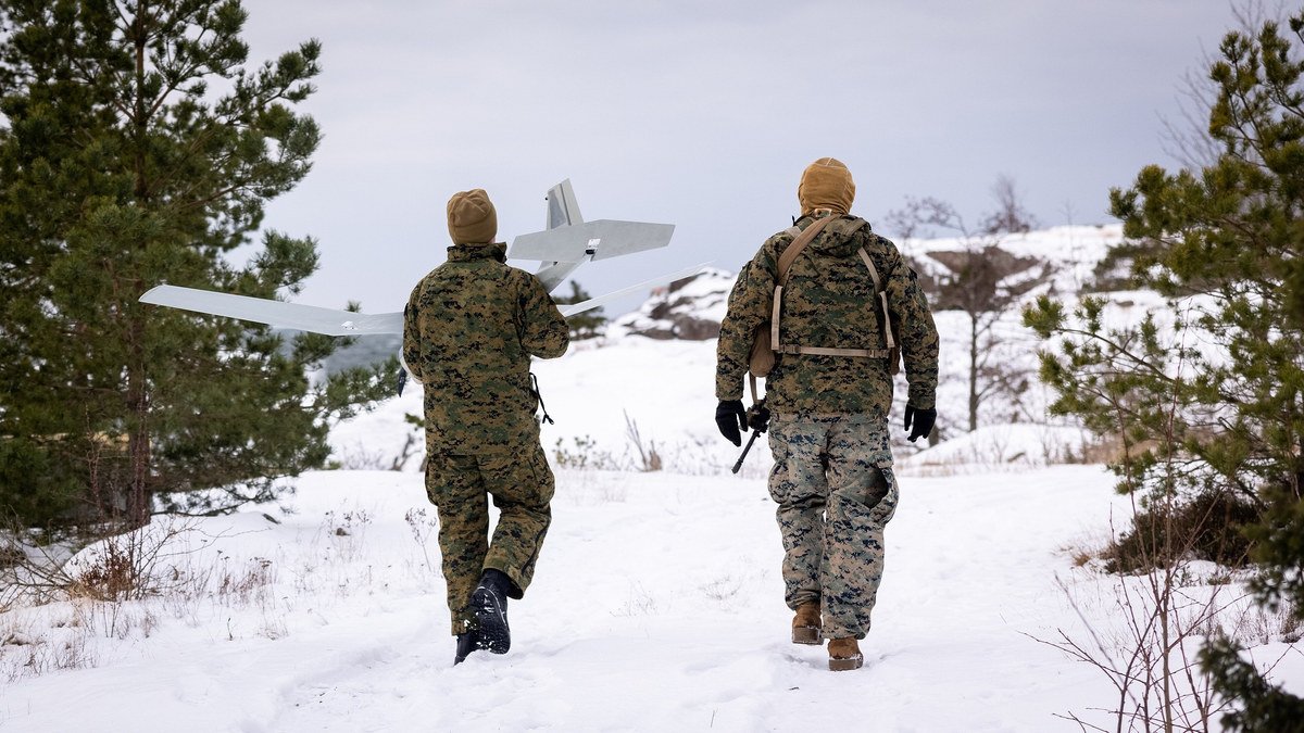
Two U.S. Marines carry an RQ-20 Puma unmanned aircraft through snow in southern Finland in support of Baltic Sentry, February 21, 2025. Photo: Lance Cpl. Brian Bolin Jr., U.S. Marine Corps, public domain, via Wikimedia Commons.

Alliance planning in the region is consequently becoming more explicitly multi-domain. NATO’s 2025 maritime strategy links maritime power to sea control, sea denial, protected lines of communication, freedom of manoeuvre and the security of critical undersea infrastructure, supported by cyber and space capabilities rather than treated as a separate naval problem. Estonia’s role already extends across forward land forces, Baltic Air Policing, Baltic Sentry and cyber defence, reflecting the fact that its strategic position cannot be understood through the land domain alone.
The Operating Environment Already Extends Across Domains
A narrow focus on possible future border crossings can obscure the range of activities already taking place across the regional security environment. The relevant operating space includes land, sea, air, cyber, space, electromagnetic activity and the information environment, with actions in one domain often supporting pressure in another.
Contemporary military planning must therefore account for:
- intelligence collection and persistent surveillance across national borders;
- cyber operations against government, military and civilian systems;
- electronic warfare and disruption of positioning, navigation and communications;
- interference with maritime traffic and critical undersea infrastructure;
- unmanned systems operating on land, in the air and at sea;
- influence activities directed at political decisions, public trust and international support;
- military infrastructure and force development beyond the immediate border area;
- attacks or disruptions designed to remain below the threshold of conventional armed conflict.
These activities do not replace conventional military power. They shape the conditions in which that power might be used, affect political decision-making and test whether institutions can identify coordinated pressure before separate incidents are normalised as unrelated technical problems.
Russia is continuing to develop unmanned capabilities across its armed forces, including air, ground and maritime systems. Estonia’s Foreign Intelligence Service assesses that unmanned units are being established across Russian services and branches, including naval strike systems in the Baltic Fleet and additional UAV formations connected to the Leningrad Military District. These capabilities support reconnaissance, precision strike, engineering, logistics and maritime operations, which means that future regional planning cannot assume that the main threat would arrive as a visible armoured formation moving along a single axis.
The information environment is equally connected to geography and strategy. Russia’s current efforts to frame the Baltic Sea as a distinct “Baltic-Scandinavian macro-region” are intended to reopen channels of influence and shape how the region is discussed by researchers and policymakers. Estonia’s Foreign Intelligence Service has identified associated recommendations to interfere in domestic politics, weaken foreign, security, economic and energy policies, and exploit questions involving Russian-speaking communities, religion and historical memory. Poorly researched external commentary can unintentionally reinforce this environment when it repeats simplistic narratives about local societies, supposed unpreparedness or inevitable military outcomes without understanding the region being described.
This is why inaccurate maps and unsupported movement arrows are not merely harmless communication devices. Once repeated across media, conferences and professional networks, they can create false expectations about vulnerability, reinforcement, evacuation, escalation or likely military behaviour. They may also displace attention from activities already affecting cyber systems, navigation, infrastructure, maritime awareness and public discourse.
Serious analysis must examine how those activities interact. A disruption at sea may affect energy or communications ashore. Electronic interference may affect civilian aviation, maritime navigation and military command simultaneously. An influence campaign may exploit the uncertainty created by a physical incident. Damage to infrastructure may be followed by competing narratives intended to delay attribution or weaken political consensus. Treating each event as a separate domain problem prevents leaders from seeing the wider operational pattern.
Geography, Preparedness and Deterrence
Geography shapes preparedness because it determines which functions must continue under pressure and where dependencies are most difficult to replace. For Estonia, this includes the ability to maintain government decision-making, military command, transport, energy, communications, healthcare and public information while supporting national defence and allied operations.
Infrastructure investment must therefore reflect both peacetime efficiency and crisis requirements. A road or railway may carry ordinary civilian traffic but also form part of military reinforcement and sustainment planning. A port may support trade while also providing strategic access. A communications cable may carry commercial data while remaining essential to government and military continuity. The dual use of infrastructure creates practical advantages, but it also means that civilian resilience and military readiness cannot be planned separately.
The same applies to alliance planning. Estonia’s defence is connected to access through the Baltic Sea, operations in the Gulf of Finland, air and maritime activity involving Finland and Sweden, reinforcement through Poland and the wider NATO command structure. Geography creates these dependencies, while political and military planning determines whether they become sources of resilience or points of failure.
Deterrence depends partly on demonstrating that these relationships are understood and prepared in advance. The objective is not to claim that geography makes Estonia secure or impossible to attack. Estonia’s own intelligence assessment for 2026 states that Russia does not intend to attack Estonia or another NATO member during the coming year, while also warning that Russia’s military reform will increase its capabilities and that sustained investment is required to preserve deterrence over time. This distinction between present intent and developing capability is central to responsible defence planning.
Preparedness must therefore avoid both complacency and performative panic. Geography, intelligence, infrastructure and allied capabilities need to be assessed together so that political leaders understand where decisions are time-sensitive, where redundancy is limited and where national action depends on regional coordination.
Section Conclusion
The strategic geography of Estonia and the wider Baltic region extends well beyond the eastern land border. It includes inland waters, forests and wetlands, but also coastlines, islands, shallow seas, ports, airspace, digital networks, energy connections and the infrastructure linking the region to the rest of NATO.
Maps showing a small number of arrows across political borders do not capture this operating environment. They rarely explain terrain, mobility, sustainment, maritime access, allied dependencies or the interaction between conventional forces, unmanned systems, electronic warfare, cyber operations, infrastructure disruption and influence activities.
Geography does not provide a prediction of how a conflict would unfold. It provides the physical and strategic context within which doctrine, force posture, preparedness and alliance planning must function. Any assessment of Baltic security that ignores that context may produce a clear-looking map, but it will not produce a reliable understanding of the region.
Estonia Has Long Treated the Narva River as a Strategic Barrier
The strategic significance of the Narva region predates the modern Estonian state by several centuries. The Narva River has historically functioned as a threshold between political entities, spheres of influence and military powers moving between Northern and Eastern Europe. Its importance was recognised long before the emergence of modern nation states or contemporary military doctrines.
The medieval fortresses facing one another across the Narva River are perhaps the most visible reminder of this historical reality. Narva Castle, established by the Danes and later developed by the Livonian Order during the 13th and 14th centuries, and the Ivangorod Fortress, constructed by the Grand Duchy of Moscow in 1492, were deliberately built to control one of the most important military, commercial and political crossing points in the region. Their location was not accidental. They were designed to dominate the river crossing, control trade routes and project military power across a strategically significant frontier.
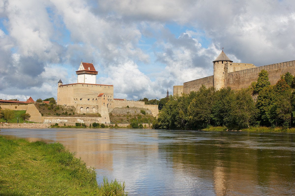
Narva Castle in Estonia, left, and Ivangorod Fortress in Russia, right, face each other across the Narva River, September 7, 2023. Photo: KalervoK, CC0, via Wikimedia Commons.

For more than seven centuries, the Narva River has served as both a connector and a barrier. Swedish, Danish, German, Russian and Estonian military planners have all recognised the same geographical realities: the terrain channels movement, infrastructure matters and control of the crossing points influences both military and political outcomes. While military technology has evolved considerably over time, the geographical characteristics that made the Narva region strategically significant in the Middle Ages continue to influence military planning today.
Estonia did not discover the military importance of the Narva River after Russia’s full-scale invasion of Ukraine, nor did the river become relevant only when modern commentators began drawing invasion arrows across it. Since the establishment of the Republic of Estonia, the Narva River, the adjoining lake system and the terrain between Lake Peipus and the Gulf of Finland have been treated as an integrated defensive environment whose principal value lies in restricting movement, concentrating an adversary onto identifiable approaches and buying time for national mobilisation and organised defence.
This understanding was already evident during the Estonian War of Independence. The defence of the Narva front in late 1919 helped Estonia resist Soviet military pressure while peace negotiations were taking place in Tartu. The location of the eventual border was therefore not only a diplomatic or territorial question. Estonian military leaders understood that freedom to prepare and defend the western bank of the Narva River was essential for the survival of a small state facing a much larger eastern neighbour. Commander-in-Chief Johan Laidoner argued during the negotiations that Estonia required freedom of action on the river’s western bank because military operations from the east had to be countered through fortifications, engineering and other technical measures.
The first post-war eastern-border defence plan was prepared by the Engineer Corps administration in March 1920. During the autumn of that year, field fortifications inherited from the War of Independence were reorganised, and new positions were developed west of the Narva River between Lake Peipus and the Gulf of Finland. By 1922, Estonia’s eastern defensive system had reached a level of development that was not subsequently matched during the interwar period, largely because defence budgets were too limited to maintain and expand all planned positions.
Successive defence plans nevertheless continued to treat the Narva region as a connected operational space rather than a single line along the river. Plans developed during the 1920s and 1930s combined permanent fortifications, field positions, artillery, mobility restrictions, prepared demolitions and the use of terrain further inland. Four reinforced-concrete bunkers were constructed near Agusalu in 1934 to protect the only road leading inland from the upper Narva River. Their placement demonstrated that Estonian planners were not simply attempting to hold the waterline itself. They were analysing how an adversary might bypass, turn or penetrate the river positions and were fortifying the limited routes that the surrounding wetlands, forests and waterways left available.
The plans also recognised that infrastructure could become either an enabler of defence or an advantage for an attacker. A detailed 1933 scheme envisaged destroying bridges, culverts, road constrictions and sections of the transport network during a withdrawal. It also proposed blocking the flow of selected rivers to create artificial flooding and expand waterlogged terrain that would restrict the use of military vehicles. The planned demolition zone extended approximately 35 to 50 kilometres westward from the border towards the Jõhvi-Kauksi line. Its purpose was to reduce the speed and weight of an offensive, limit the use of manoeuvre formations and provide time for Estonia to organise subsequent defensive operations.
This was not based on the assumption that the Narva River was impassable. Estonian planners identified four principal sectors in which an eastern attack might be attempted: Narva, Kriuša, Vasknarva and Narva-Jõesuu. These covered the bridges and roads around Narva, possible flanking routes towards Auvere, approaches from the upper river and Lake Peipus, and a northern option supported by an amphibious landing near Narva Bay. The defence plan therefore considered river crossings, inland manoeuvre, lake approaches and coastal operations together rather than treating the eastern border as an exclusively land-based problem.
The Narva River served as the principal defensive line on Estonia’s northern front, while the Sinimäed hills were designated as a reserve position because they provided a shorter defensive frontage. Mobile reserves were intended to respond to land penetrations as well as airborne, maritime and lake-borne landings behind the front. The purpose of the covering forces was not to defeat the entire Red Army independently at the border. They were expected to hold the Narva line for at least four days, which Estonian planners calculated would be necessary to complete national mobilisation and move the main forces into position. Geography was therefore incorporated into a wider system of readiness, mobilisation, infrastructure denial and force generation.
The interwar plans also reveal the limits of terrain when it is not supported by investment, secrecy and trained forces. Funding for border fortifications remained inconsistent, and several planned projects were delayed or never completed. In 1938, work was interrupted after Captain Nikolai Trankmann, who had supervised fortification activity in the Narva area, was convicted of passing defensive plans to the Soviet Union. The designs and locations of the positions then had to be revised. The episode underlined that a natural obstacle provides only part of a defensive advantage. Intelligence security, engineering capacity, mobilisation, fire support and sustained political investment determine whether that advantage can be converted into operational effect.
The same underlying logic remains visible today, although the political, technological and alliance context is fundamentally different. Estonia is no longer planning an isolated national defence based on interwar positional warfare. It is a NATO member implementing forward defence through national forces, allied regional plans and multi-domain capabilities. The current Baltic Defence Line reflects deterrence by denial and is intended to strengthen defence from the first metre of Allied territory through an integrated system of obstacles, field fortifications and prepared support points. Estonia’s plans include up to 600 squad-level bunkers, storage areas for rapidly deployable barriers such as concrete anti-vehicle obstacles and concertina wire, and supporting anti-tank ditches. Their placement is being determined through environmental analysis, operational planning, local terrain and consultation with landowners rather than by constructing an uninterrupted wall along the political border.
This continuity should not be mistaken for the repetition of an old defence plan. Interwar Estonia sought to gain several days for national mobilisation using a largely static defensive concept. Contemporary Estonia must integrate territorial defence, allied reinforcement, precision fires, air and missile defence, engineering, unmanned systems, electronic warfare, maritime awareness, cyber defence and civilian continuity. Natural barriers still shape where forces can move, but they now exist within an operating environment in which the approaches to the river, bridges, roads, command systems and engineering activity may be observed and targeted from considerable distance.
The Narva River is also more than a prospective military obstacle. It is an active state border, a shared waterway, a source of energy and a space in which pressure can be applied below the threshold of armed conflict. In May 2024, Russian border guards removed 25 navigation buoys placed by Estonia in the river. The Estonian government described the incident as part of a broader Russian pattern of using border questions to generate uncertainty and anxiety. The episode did not alter the military geography, but it demonstrated how the same physical environment can simultaneously become a legal, administrative and information-security issue.
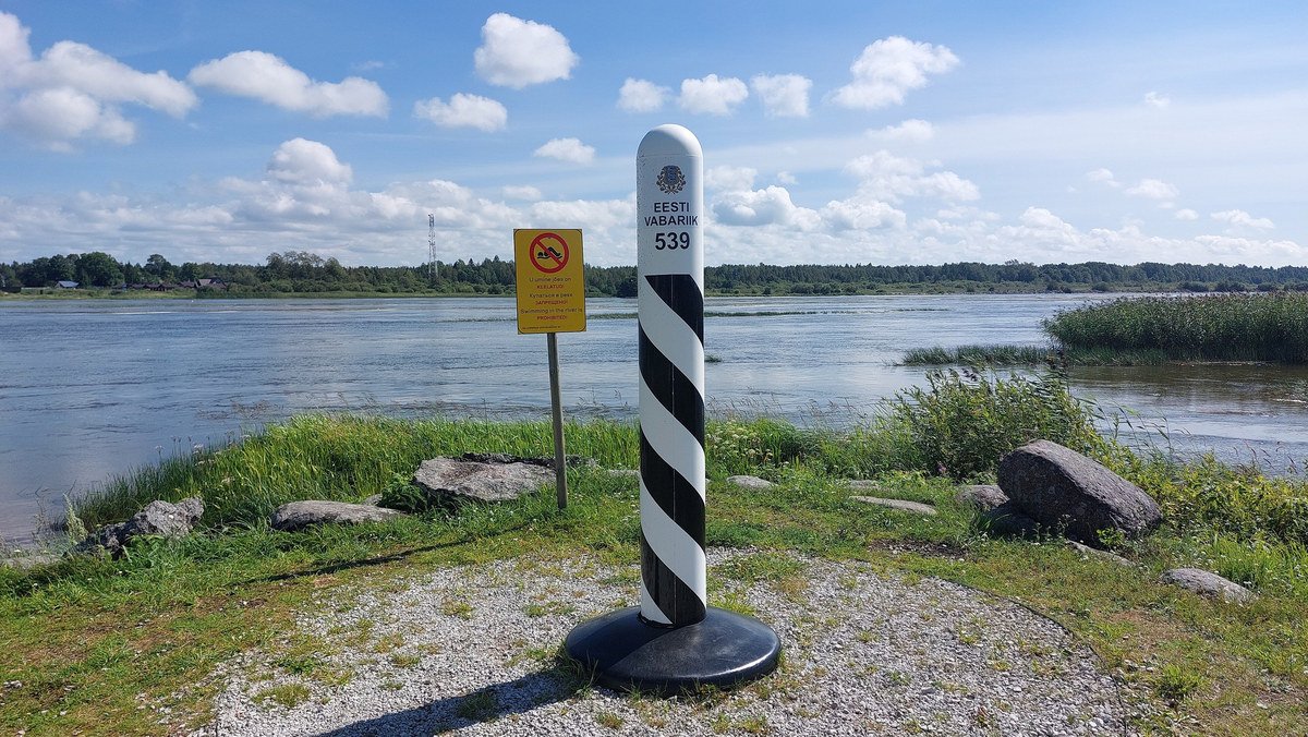
Estonian boundary stone 539 on the bank of the Narva River at Vasknarva, August 5, 2023. Photo: 5R-MFT, CC BY-SA 4.0, via Wikimedia Commons.

Estonia’s historical approach to the Narva region has therefore never rested on the belief that a river can defend the country by itself. The river and adjoining lake system were valuable because they narrowed the available approaches, increased engineering requirements, channelled movement and created time. Estonian planning then sought to reinforce those natural effects through fortifications, prepared demolitions, artificial flooding, mobile reserves and mobilisation.
Contemporary defence planning follows the same practical principle while applying it within a very different military system. Terrain does not replace forces, alliances or technology, but it influences where those capabilities are required and how effectively they can be used. Estonia has understood this for more than a century. Any analysis presenting the Narva River as a line that an armoured formation can simply cross on its way west ignores not only the physical geography, but also the strategic purpose for which Estonia has repeatedly planned to use it.
Conclusion
Discussions about Baltic security often begin by asking how a conflict in the region might unfold. In practice, that question is frequently asked before understanding the geographical, historical and operational realities that shape the region itself.
The Baltic States are not a single strategic entity. Their geography, infrastructure, historical experiences and military considerations differ significantly despite their shared security interests and close regional cooperation. Understanding those differences is fundamental to understanding how defence planning, preparedness and alliance planning are approached across the region.
Military geography has not become less important because warfare has become multi-domain. If anything, geography now intersects with infrastructure, cyber capabilities, critical dependencies, maritime security, logistics, intelligence, unmanned systems and information operations in ways that make strategic assessments considerably more complex than political maps alone can convey.
Rivers remain rivers. Wetlands remain wetlands. Coastlines, islands, maritime approaches, infrastructure corridors and environmental conditions continue to influence military mobility and operational planning regardless of technological developments. Modern military capabilities have changed how military operations are conducted. They have not eliminated the physical realities within which military operations take place.
Political maps are useful for understanding where borders are. They are considerably less useful for understanding how military operations, deterrence and defence actually work.
One of the recurring challenges in discussions about Baltic security is the tendency to treat Estonia as “the Baltics”, the Suwałki Gap as “the Baltics” or a single military scenario as representative of the entire region. The Baltic States share strategic interests, but they are not interchangeable security problems. Geography alone should make that immediately apparent.
Part 1 has deliberately focused on geography rather than adversaries. Before discussing military capabilities, escalation scenarios or regional vulnerabilities, it is worth understanding what the Baltic region actually is. Strategic analysis becomes considerably more useful when conclusions are drawn after asking the relevant questions rather than before.
The remaining parts of this series will build upon that foundation by examining military mobility and regional dependencies, maritime and alliance considerations, and the realities of contemporary multi-domain security in the Baltic region.
Coming Next in the Series
Part 2 – Beyond the Red Arrows: Military Mobility, Regional Dependencies and Reinforcement Realities
Topics include:
- The Suwałki Gap myth and operational realities.
- Military reinforcement in the Baltic region.
- NATO’s regional plans and what they actually mean.
- Finland and Sweden’s significance for Baltic security.
- The Baltic Sea as both connector and vulnerability.
- Ports, railways, roads and logistics corridors.
- Civilian and military infrastructure dependencies.
- Why evacuation and population movement are rarely discussed realistically.
- Alliance planning and regional interoperability.
Questions addressed:
- How would military mobility and reinforcement actually work?
- Why is the Baltic Sea as important as land corridors?
- What assumptions are hidden behind reinforcement scenarios?
- What role do allies play operationally?
Part 3 – Multi-Domain Reality: Contemporary Security in the Baltic Region
Topics include:
- Maritime security.
- Air and missile defence.
- Critical infrastructure.
- Electronic warfare.
- GNSS interference and GPS spoofing.
- Undersea cables and energy infrastructure.
- Cyber operations.
- Information operations and influence activities.
- Hybrid activities below the threshold of armed conflict.
- Unmanned systems and changing operational realities.
Questions addressed:
- What security activities are already taking place today?
- What does contemporary multi-domain security actually look like?
- How do civilian and military infrastructures intersect?
- How do states operate below the threshold of armed conflict?
Part 4 – Deterrence, Preparedness and Strategic Realities
Topics include:
- Deterrence by denial.
- Total defence and comprehensive security.
- National resilience.
- Alliance planning.
- Defence investments.
- Regional cooperation.
- Strategic communications.
- Lessons from history.
- Future challenges for the Baltic region.
Questions addressed:
- What does deterrence actually mean in the Baltic context?
- What should political and military leaders be asking?
- What assumptions should be challenged?
- What capabilities and partnerships matter most going forward?
Recommended Reading
Baltic Security and Defence
NATO Regional Defence and Deterrence https://www.nato.int/cps/en/natohq/topics_133127.htm
NATO’s Deterrence and Defence https://www.nato.int/cps/en/natohq/topics_133127.htm
NATO Baltic Sea Security and Baltic Sentry information https://shape.nato.int
Estonian Ministry of Defence publications https://kaitseministeerium.ee/en
Estonian Defence Forces Yearbooks https://kaitseministeerium.ee/en/national-defence-and-society
Intelligence and Security Assessments
Mandatory reading in my opinion.
Estonian Foreign Intelligence Service – International Security and Estonia (all annual reports since 2016) https://valisluureamet.ee/assessment.html
Estonian Internal Security Service (KAPO) Annual Reviews https://kapo.ee/en/content/annual-reviews/
Estonian Information System Authority (RIA) Cybersecurity Annual Reports https://ria.ee/en/node/3738
Latvian State Security Service publications https://vdd.gov.lv/en
Lithuanian Intelligence Threat Assessments https://www.vsd.lt/en
Finnish Security and Intelligence Service (SUPO) publications https://supo.fi/en/frontpage
Military Geography and History
Estonia
Books and materials:
Mart Laar – War in the Woods: Estonia’s Struggle for Survival, 1944–1956.
Mart Laar – Estonia in World War II.
Toomas Hiio (editor) – Estonia Since 1944.
Estonian War Museum publications.
Estonian National Archives collections.
Websites:
Estonian War Museum https://esm.ee/en/
Estonian National Archives https://www.ra.ee/en/
Narva River as a Strategic Barrier in the Republic of Estonia period (excellent historical analysis in Estonian) https://teejuht.esap.ee/pohja-eesti/narva-jogi-strateegilise-tokkena-eesti-vabariigi-ajajark/
Finland
Henrik Meinander – A History of Finland.
William R. Trotter – A Frozen Hell: The Russo-Finnish Winter War.
Finnish National Defence University publications. https://maanpuolustuskorkeakoulu.fi/en
Latvia
Latvian War Museum publications.
Latvian National Library historical collections. https://karamuzejs.lv/en
Lithuania
Lithuanian Military Academy publications. https://www.lka.lt/en/
The Baltic Sea and Regional Security
Mandatory reading.
Baltic Sea Action Plan and regional environmental materials.
NATO Maritime Strategy.
Baltic Defence College publications. https://www.baltdefcol.org/
Centre for Military Studies (University of Copenhagen). https://cms.polsci.ku.dk/english/
Swedish Defence University publications. https://www.fhs.se/en.html
Finnish Institute of International Affairs. https://fiia.fi/en
International Centre for Defence and Security (ICDS). https://icds.ee/en/
RAND Europe publications on Baltic security. https://www.rand.org
CSIS publications. https://www.csis.org
RUSI publications. https://rusi.org
Suggested Reading for Military Geography Nerds (Highly Recommended)
The Great Northern War.
The Battle of Narva (1700).
The Battle of Narva (1944).
The Estonian War of Independence.
The Finnish Winter War.
Baltic Sea naval history.
The development of the Baltic Defence Line.
NATO’s regional defence plans.
Finnish Comprehensive Security.
Swedish Total Defence.
Estonia’s Total Defence and Comprehensive Security approach.
Military engineering and river crossing operations.
Logistics and sustainment in contemporary warfare.
Military geography and terrain analysis.
Russian military reforms and force development.
Unmanned systems in contemporary warfare.
If this article encouraged you to open a map, read a historical source or challenge one of your assumptions about the Baltic region, it has served its purpose.
Recommended Field Trip: Understanding the Baltic and Nordic Security Environment
Estonia
Military history and strategic geography
Estonian War Museum (Viimsi)- Estonian War of Independence, WWIISoviet occupation, Contemporary defence developments, Outdoor military equipment collection
Narva Museum and Narva Castle - Narva River as a strategic threshold, Medieval military historySwedish periodRussian periodBorder history and military geography
Sinimäed Museum- Battle of Narva 1944 Military geography of the Narva front Terrain and defensive positions
Estonian National Archives- Military planningInterwar defence plans, Historical maps and documents
Finland
Total Defence and military resilience
Military Museum of Finland (Helsinki)- Finnish military history, Winter War, Continuation War, Modern defence concepts
Suomenlinna Fortress- Baltic Sea defence, Russian and Swedish military history, Coastal defence
Finnish National Defence University- Defence publications, Total Defence concepts, Comprehensive Security model
Sweden
Baltic Sea and Total Defence
Swedish Army Museum (Stockholm)- Swedish military history, Baltic region history, Great Northern War, Total Defence concepts
Vasa Museum- Naval power in the Baltic Sea, Maritime history, Military shipbuilding
The Naval Museum (Karlskrona)- Baltic naval strategy, Swedish maritime history, Coastal defence
Latvia
Occupation history and national resilience
Latvian War Museum (Riga)- Latvian military historyIndependence wars, WWII and Soviet occupation, Contemporary security developments
Museum of the Occupation of Latvia- Soviet and Nazi occupations, National resilience, Historical context for Baltic security
Lithuania
Military history and strategic geography
Vytautas the Great War Museum (Kaunas)- Lithuanian military history, Independence, Occupation history, Contemporary defence
Lithuanian Military Academy publications and public materials
Poland
Regional strategic context
Warsaw Rising Museum- Urban warfare, Resistance, National resilience
Museum of the Second World War (Gdańsk)- Baltic Sea strategic history, European military history, Maritime perspectives
Denmark
The Baltic Sea gateway
Danish War Museum (Copenhagen)- Danish military history, Baltic and North Sea strategic geography, NATO and contemporary defence
Recommended Historical Sites
If you are travelling in the region, the following locations are worth seeing in person:
Narva River and Narva Castle.
Sinimäed Hills.
Lake Peipus.
Suomenlinna Fortress.
Karlskrona naval base.
The Åland Islands.
Gotland.
Gdańsk.
Copenhagen harbour and maritime museums.
Tallinn Old Town fortifications.
Paldiski.
The Gulf of Finland coastline.
Recommended Books
Military Geography and Baltic Security:
Colin S. Gray – The Geopolitics of Super Power
Geoffrey Parker – The Cambridge History of Warfare
Martin van Creveld – Supplying War
Williamson Murray and Allan Millett – Military Innovation in the Interwar Period
Lawrence Freedman – Strategy: A History
Mart Laar – War in the Woods
William R. Trotter – A Frozen Hell
Henrik Meinander – A History of Finland
Baltic Region:
Mart Laar’s works on Estonian military history.
Baltic Defence College publications.
ICDS publications.
Finnish Institute of International Affairs publications.
Swedish Defence University publications.
NATO and NATO CCDCOE publications.
Eva Sula is an independent defence and security strategic advisor specialising in NATO and European defence cooperation, regional security, emerging technologies and operational capability development. She is a NATO DIANA Defence Mentor, a Senior Fellow for Estonia at the Council on Strategic and Foreign Intelligence (CSFI), and a member of The Alphen Group.
© Eva Sula
First published on LinkedIn on July 17, 2026. Read the original article or the LinkedIn post.
All opinions expressed are those of the author alone and may not represent those of the institutions they represent or the Baltic International Security Centre (BISC). BISC maintains a strict intellectual independence policy across all its projects and publications.